During the last glacial period, much of Bass Strait was a vast sandy and windswept plain. In the eastern region, this formed a continuous land bridge between what is now Lutruwita/Tasmania and Victoria, including the prominent landscape features of Yiruk/Wamoon/Wilsons Promontory in Victoria, Hogan Island, Tayaritja/the Furneaux Group of Islands (including Flinders Island) and Cape Portland in Lutruwita/Tasmania.
While the islands themselves would have been rocky hills providing significant refuge, large stretches of this land bridge were open sandy plains with very little shelter from the elements for the Old People of the time.
However, recent seabed mapping has revealed the presence of a hidden reef system that would once have been a long rocky ridge offering protection from freezing ice age winds for people travelling between the peaks that are now Deal Island and Hogan Island.
The submerged land bridge crossing section between Hogan Island and Deal Island now forms part of the Beagle Marine Park, a marine protected area in the eastern Bass Strait.

About the Authors


With thanks to
This research was undertaken for the Marine Biodiversity Hub and Marine and Coastal Hub, collaborative partnerships supported through funding from the Australian Government’s National Environmental Science Program (NESP). With thanks to the Institute for Marine and Antarctic Studies (IMAS), Geoscience Australia, Australian Centre for Field Robotics (ACFR), the Australian Integrated Marine Observing System (IMOS), and Parks Australia.


The reef is now 60 metres below the surface of Bass Strait and is home to a diverse array of marine species. But it was once a series of sand dunes. The signature parabolic U-shapes of windswept dunes are part of the reef and still clearly preserved. Over the ages the dunes turned into a limestone-like rock in a process called calcification, where sand slowly turns into stone after being exposed to freshwater. When these hardened dunes eroded, they formed a series of ledges and caves and boulder fields extending over 15 kilometres, to a width of approximately 300 metres and a height of around 5 metres. They likely provided a welcome respite from the elements for those on the Bassian Plain in the time of the land bridge.
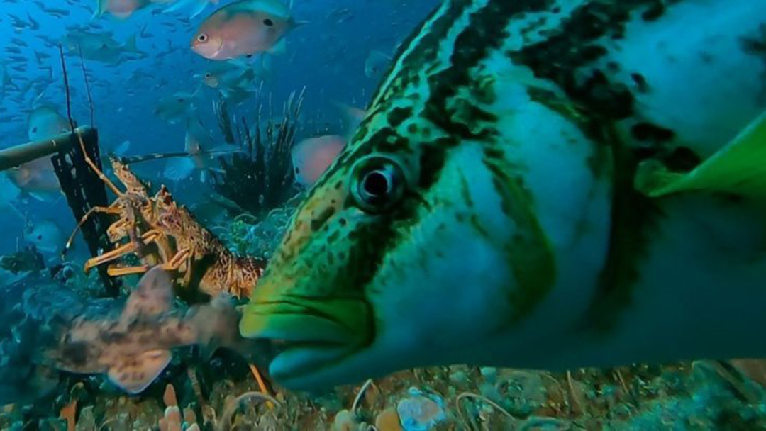
While the sandy seafloor is utilised by marine life, it is relatively sparsely populated because it is so exposed to the currents. This is why it is like a desert. But the reef, like an oasis, is covered in life. It boasts a colourful array of sponges, ascidians –animals also known as sea squirts which permanently attach themselves to the reef, coral-like bryozoans, and corals, including large fan-like gorgonian corals which bend majestically as the current flows. The coral and sponge gardens draw a diversity of fish, shellfish and other marine life attracted to the shelter and food. In winter the reef also appears to provide shelter for a large group of Port Jackson sharks, which are grey blunt-headed seafloor-dwellers with prominent eyebrow ridges and brown stripes. They presumably migrate here to feed on a range of shellfish species on the adjacent sandy seabed at this time.


Our survey was the first time the underwater world of Beagle Park had been mapped in detail. The data and imagery we collected can now act as a benchmark, or point in time reference, so that the health and diversity of the marine environment can be monitored again in the future.
The AUV imagery hosted on SQUIDLE+ and a selection of BRUVS footage, in addition to the seabed mapping, is now available to be seen on the public-access website Seamap Australia. This allows everyone with an interest in the ocean and marine parks the opportunity to explore the unique seabed and marine life of the Beagle Marine Park and share our appreciation of the values of this special place.


Copyright information
Released under a Creative Commons Attribution Non Commercial No Derivatives 4.0 International (CC BY-NC-ND 4.0) license.
This story is subject to disclaimers, copyright restrictions, and cultural clearances. Copyright © Neville Barrett, Jacquomo Monk, 2024.
Further reading
Friedman, A (2024) SQUIDLE+ Map, Understanding Marine Imaging Facility (UMI) & Integrated Marine Observing System (IMOS), accessed 30 June 2024.
Nanson R, Huang Z, McNeil M, Carroll A (2023) Seabed morphology and geomorphology of the Beagle Marine Park, south-eastern Australia – Version 1, Geoscience Australia, Canberra, https://dx.doi.org/10.26186/147976
Nichol S, Barrett N, Beaman, R, Siwabessy J, Spinoccia M (2019) Beagle Marine Park bathymetry survey 2018 (GA0364), Geoscience Australia, Canberra, http://dx.doi.org/10.26186/5d4cea0bdecb4
Parks Australia (2024) Beagle Marine Park, Parks Australia, accessed 30 June 2024.
Parks Australia & Australian Institute of Marine Science (2024) Beagle Marine Park, Australian Marine Parks Science Atlas, Parks Australia, accessed 30 June 2024.
Seamap Australia (2024) Data Report, South-east Region: Beagle, Institute for Marine & Antarctic Studies (IMAS), University of Tasmania, accessed 30 June 2024.
Seamap Australia (2024) Seamap, Institute for Marine & Antarctic Studies (IMAS), University of Tasmania, accessed 30 June 2024.